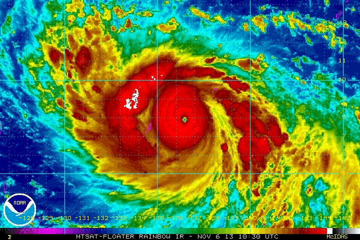
Radar loop of Super Typhoon Haiyan intensifying. Image Credit: NOAA
The 2013 Western Pacific Ocean remains quite active in the tropics. Right now, we’re keeping a close eye on Super Typhoon Haiyan. Super Typhoon Haiyan, (or Yolanda, which is the name given the storm by the Philippines) is producing sustained winds of 160 mph (140 knots.) It is considered a Category 5 storm on the Saffir Simpson scale. Haiyan is a powerful storm that will hit the Philippines on Friday around 0-6 UTC. The Joint Typhoon Warning Center believes this storm will still be a powerful Category 4 storm with sustained winds around 145 mph (125 knots) when it hits. If you live in the Philippines, you need to know that this storm could be devastating and you must prepare now.Haiyan will become the fifth storm to directly affect the Philippines this year. According to Jeff Masters of Weather Underground, four storms have directly impacted the Philippines killing 30 people.
The strongest of these, Typhoon Utor, which had sustained winds of 140 mph, hit the Philippines on August 12, 2013 and cost $25 million dollars in damage. The Philippines typically average eight to nine storms per year, so activity has been slightly below average. However, the overall Western Pacific Typhoon season has been very active, especially north of the Philippines. So far in 2013, we have seen 28 named storms. The last time we had this much activity was back in 2004, when we recorded 32 named storms. In general, the Western Pacific is an area likely to spawn some of the strongest tropical cyclones in the world.
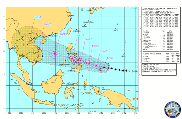
Potential track of Super Typhoon Haiyan. Image Credit: Joint Typhoon Warning Center
Haiyan will continue to push to the west-northwest and push into the Philippines by Friday morning. Haiyan has significantly strengthened over the past 24 hours from a minimum typhoon to a super typhoon. It has great outflow and very deep convection with a symmetric eye. It is likely that Haiyan will slightly weaken as it undergoes an eyewall replacement cycle. For now, the Joint Typhoon Warning Center is expecting Haiyan to strike the Philippines as a Category 4 storm with sustained winds of 145 mph. Haiyan has the potential to create significant damage, flooding, and mudslides along a very populated area.Bottom line: Super Typhoon Haiyan will slam into the Philippines Friday morning and produce damaging winds and flooding rains. Evacuations are already underway as the storm pushes to the west-northwest at 20 mph. Heavy rain, damaging winds, flooding, and mudslides are likely as it pushes over the country Friday.
source and credit a earthsky
Comentarios
Publicar un comentario